Large Scale Dynamic Flood Forecasting
Recent extreme floods in the United States (1993, 2011), China (1998), United Kingdom (2000, 2003), Pakistan (2010), Europe (1995, 2010) and Thailand (2011) highlight the importance of understanding the hydro-meteorological processes responsible for these extreme flood events and the associated temporal and spatial characteristics of sequences for the associated precipitation events
“Professor Lall and the Columbia Water Center possess deep domain expertise in global water risk management topics – whether the risk is due to floods or drought. When we worked on a climate informed flood risk initiative, Professor Lall was able to quickly pull together a multi-disciplinary research team across various institutes to contribute to various aspects of the project. In a very short time, the team was able to deliver cutting edge and impactful research insights.”
– Vijay Manghnani, Funder
Development of a Dynamic Flood Forecasting Model Based on Large Scale Climatic Information
Various climate change projections suggest an intensification of precipitation in the future, in terms of both frequency and magnitude. The intensity of extreme precipitation is projected to increase under global warming in many parts of the world. However, these arguments are driven largely by considerations of the moisture holding capacity as a function of temperature, as indicated by the Clausius-Clapeyron equation. One also needs to consider the attendant atmospheric circulation and moisture transport dynamics that lead to persistent extreme precipitation and subsequent flooding as evidenced in recent major floods.
Although the climate mechanisms governing precipitation vary by location, extreme precipitation events in the mid-latitudes are typically associated with anomalous atmospheric moisture from warmer tropical or subtropical oceanic areas. Enhanced Integrated Water Vapor (IWV) bands, also known Atmospheric Rivers (ARs), are associated with direct poleward transport of tropical moisture along the IWV bands from the Tropics all the way to the extratropics. For meridional transport at middle latitudes, ARs account for a substantial part of the moisture transport. The AR concept indicated a direction to track the moisture from warmer oceanic source to the heavy precipitated regions. Stationary Rossby waves account for a substantial fraction of summertime monthly mean surface temperature and precipitation variability over a number of regions of the Northern Hemisphere middle latitudes. Tropical moisture exports (TMEs) to the Northern Hemispheric extratropics are an important feature of the general circulation of the atmosphere and link tropical moisture sources with extratropical precipitation and occasionally with explosive cyclogenesis.
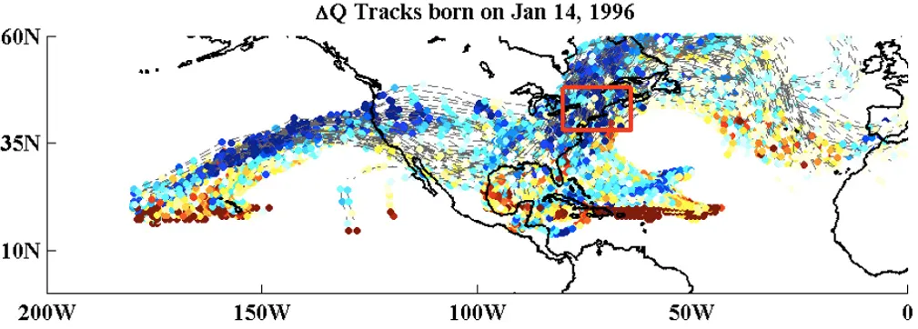
TME tracks were calculated based on 6-hourly ERA-Interim data for 42 flood events from 1989 – 2010 in the Northeastern United States
Tropical Moisture Sources
There are four tropical regions that were identified as major moisture
sources for the northern hemisphere:
- “Great Plains” (GP), A locally very confined maximum occurs between
the Rocky and the Appalachian Mountains; The inflow of moist air masses
from the Gulf of Mexico (0-20°N, 100°W-90°W)into the central parts of
the United States. - “Pineapple Express” (PE),(0-20°N, 160°W-150°W) connects the tropics
near Hawaii with the North America. - “Gulf Stream”, (GS), (0-20°N, 60°W-40°W) located over the western inflow
region of the North Atlantic storm track along the east coast of North
America. - “West Pacific” (WP), (0-20°N, 130°E-150°E) presumably closely related to
the mei-yu-baiu front over East Asia during Summer time.
Summary
Contributions of the moisture born in the four hotspots have distinctive seasonal patterns. The “Great Plains” Hotspot is the major year-around moisture source to the Northeast region, corresponding to the moisture born in Gulf of Mexico. The trajectories of the tracks have seasonal variations, suggesting the role of atmospheric circulation in bring the moisture from the tropics. There is also a strong association between TME tracks and flood events year-around, with the least association during Summer, and the strongest association in Winter.
Next Steps
A complementary analysis on the whole country is being performed to understand the role of large scale transport of moisture associated with floods. Research on associating stationary waves and transients with these tracks and their convergence is in progress, both for understanding the antecedent and concurrent dynamics and for prognostic modeling.
Reference
Lu, M., U. Lall, A. Schwartz, and H. Kwon (2013), Precipitation predictability associated with tropical moisture exports and circulation patterns for a major flood in France in 1995, Water Resour. Res., 49, 6381–6392, doi:10.1002/wrcr.20512.