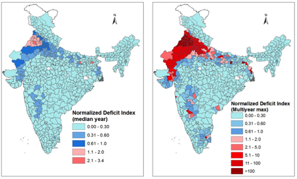
Given the magnitude of India’s chronic water problems, current and planned water storage capacity is woefully inadequate for those who depend on it. While appropriately planned water storage can theoretically provide greater protection for farmers and other users against dry spells, one question begs further scientific scrutiny:
What criteria should policy makers apply when choosing between centralized storage (in the form of conventional large reservoirs and large interbasin water transfer programs) and decentralized and distributed storage systems in farmers’ fields and villages?
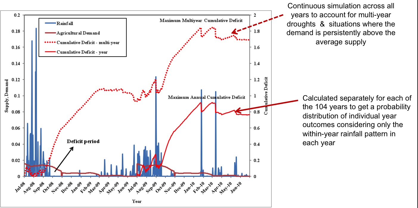
The Columbia Water Center’s study attempts to bridge this crucial gap in scientific understanding. Using sophisticated statistical modeling coupled with spatially informed GIS overlays, CWC scientists have developed an estimate of regions especially vulnerable to both short and long-term water shortages in India. Using 100 years of temperature and precipitation data, the nationwide Potential Storage Index (PSI) models both the magnitude and potential for water storage in low and moderately water-stressed areas as well as critically water scarce regions. The PSI is based on the sequent peak algorithm commonly used for sizing and operations of reservoirs to quantify the water storage capacity needed to meet the different demands for a given stochastic realization of supply (i.e. the storage capacity needed to meet variable water demand at any given point in time).

Deficit in this study is defined as the difference between the water demand and maximum renewable water supply. By designing the system for the worst dry periods (based on the historic records) in the sequence, the sequent peak method provides a robust measure of the ability to meet demand without failure. The analyses have been done at the level of district–the smallest administrative unit in the country for which the required data are available.
From the estimates, it is evident that while sufficient water may be available on average, periods of excess are followed by periods of deficit. In most of the core monsoon regions in India (which predominantly supports rainfed agriculture), the season is approximately 90 days long and is marked by roughly 10 to 15 major rainfall events. Hence, there is a need to quantify water stress in such regions as a measure of resilience of the system to these periodic shocks (both from extended dry spells within years and long-term drought across years) in water availability.
The results show that many regions receive enough rainfall to supply their needs, as long as they build more reservoirs, ponds, and tanks to store water when supplies are plentiful. Other, more critically stressed regions will need to invest in large-scale storages such as dams and water transfer infrastructure to cover periods of intense shortfalls and variability in supply. In both cases, storage is needed to bridge the intense monsoonal storms that punctuate the long dry spells in the country.
Spatial Optimization of Cropping Patterns in India
Based on the climate-informed spatial and temporal assessments of the magnitude of water deficits in India, the CWC team has been exploring ways to manage water use and demand. In an agrarian economy such as India’s, water demand is dominated by irrigation needs, which have consequently received the highest governmental infrastructure priority over different national plan periods. Against this background, CWC researchers are assessing the potential to alter existing cropping patterns to reduce regional and national water stress, examining the potential socio-economic implications of such changes and devising strategies for the practical implementation of results.
One of CWC’s major research initiatives has been to develop systematic solutions to water/food/energy/security challenges at a national scale in the face of climate variability. Given the current patterns of excessive irrigation and groundwater withdrawal in regions of intense water deficits, CWC scientists have developed a methodology to inform a strategic shift of the cropping patterns across India using a Deficit Simulation Optimization Model (DSOM) under a purely rainfed basis. The objective of the model is to maximize the aggregate national agricultural revenue while meeting the national food security goals and preserving sustainable water supply. To do so, the model identifies the regions and crop choices that can support area expansion and productivity enhancement in a sustainable manner.
Preliminary results suggest that by replacing intensive grain production in more developed but water-stressed regions with other crops (including pulses and vegetables), while simultaneously shifting grain production to less water-stressed but economically poorer regions, an optimized agricultural policy could increase income, meet nutritional needs and national self-sufficiency without reducing total food production.
It is believed that such a systematic analysis of optimal cropping patterns based on the understanding of the magnitude of water stress will lead to significant water savings in the country. It will also provide scientific stimulus at the national scale to inform policy regarding feasible crop choices that can support productivity expansion and enhancement while maintaining food and nutritional security in the country.
For more information on the India Water Stress Index, watch presentations by Columbia Water Center researchers Shama Perveen and Naresh Devineni given at the 2010 American Geophysical Union meeting.
